Please log in to read this in our online viewer!
Please log in to read this in our online viewer!
No comments yet. You can be the first!
What did others read after this?


Content extract
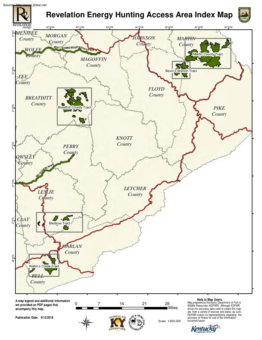
Source: http://www.doksinet Revelation Energy Hunting Access Area Index Map 37°50'N 83°30'W 83°20'W MENIFEE County 83°10'W 83°0'W 82°50'W MORGAN County BE R T T C OMBS-MOUNTAI N P WOLFE County 82°40'W JOHNSON County K W Y EXT 82°20'W MARTIN County Mar t i nCount y Tr act MAGOFFIN County 37°40'N 82°30'W Bevi n’ sBr anchTr act BREATHITT County FLOYD County Br eat hi t tCount y Tr act 37°20'N 37°30'N LEE County PIKE County KNOTT County PERRY County ER Y KW SP OG OWSLEY County R 37°10'N L HA LETCHER County CLAY County Bl edsoeTr act HARLAN County 36°50'N 37°0'N LESLIE County Wal l i n’ sCr eekTr act BELL County A map legend and additional information are provided on PDF pages that accompany this map. Publication Date: 9/13/2018 0 ® 7 14 21 28 Mi l es Scal e 1: 600, 000 Note to Map Users Map prepared by Kentucky Department of Fish & Wildlife
Resources (KDFWR). Although KDFWR strives for accuracy, data used to create this map are from a variety of sources and dates; as such, KDFWR makes no representations regarding the accuracy or fitness for use of the information furnished herein. Source: http://www.doksinet 82°33'W 82°30'W 82°29'W ork F o rk o ad n Ba r k 82°31'W W f ol 82°27'W Cre 82°26'W 82°25'W 82°24'W 82°23'W 82°22'W 82°21'W 82°20'W Tu g ek F ork R ch McClure 37°46'N r an ork log B kF Ash O County Boundary Oa ld F 82°28'W ite Legend n Ly 82°32'W Wh 37°47'N 82°34'W Revelation Energy Hunting Access Area - Martin County + Elk Fork Threeforks ! k eek g Cr ily Chaffin k Br an ch Rural C re ek is av PIKE County rk J u d e F Fo or Mouth of Long Fork (historical) an c h R o ck ho e u s F o rk k 1 y Br Elkins Fork (historical) o rk 0 r Fo M ns F k
or Left Fo rk B u Lowe (historical) ® Elk i y or Publication Date: 9/13/2018 Imagery from Farm Service Agency 2016 Heenon F ty on Banyan (historical) A map legend and additional information are provided on PDF pages that accompany this map. u B r sh y F Gin F k Fral e sh sh y L ow e Br a h nc ran ch ork k h ork B ru c an Br h B ig Swin g e Ca mp Br an c D s R F or Hurricane B Fo hn Jo rk 37°41'N Seng B ee k Cr a M a Lo wg r Fo B ig 37°40'N Em 37°45'N 37°44'N 37°43'N 37°42'N N w Co FLOYD County h Moree on Hatfield nc C aney se F ra e ho u ock B Laura k p For ch e an no Ca Fork k d Fo r na r ed dy Br u k or g Bi st May Wa sh Czar Hunting Access Area s ou th T F nr ! k e ! oo MARTIN County ! or r th Pa n e F B c ab in ch ran ch eo Pig te Wh i n ra 2 Scale 1:90,000 3 4 Miles Note to Map Users Map prepared by Kentucky Department of Fish &
Wildlife Resources (KDFWR). Although KDFWR strives for accuracy, data used to create this map are from a variety of sources and dates; as such, KDFWR makes no representations regarding the accuracy or fitness for use of the information furnished herein. Source: http://www.doksinet 82°39'W e Br n rB ra ch R i ve an an c Se ll h ers h Wo lf B r To m ra tB L M cC Dr if B Syc a nc Wo o ds Br Cr eek L ow 37°42'N 37°41'N 37°38'N h 37°37'N e C r e ek nc PIKE County om n Bra bs ch O ak Bra B ru sh y Ru n B ng Lo m or e C r e ek Legend Elk Horn Coal Hunting Access Area i te 1 Cr e ek vy Cr t t Br a e w Lo B ra nc ra nc h h County Boundary h nc ® 0 B ranch rk Gulnare h Publication Date: 9/13/2018 Imagery from Farm Service Agency 2016 Banner I vy on B r an ch Wonder W A map legend and additional information are provided on PDF pages that accompany this map. t ef I Heenon o Sc J acks ek ek
C re rk Fo h ty on ork ill F Cre n Da 23 £ ¤ Cla rk ek s Cre ie l nc M fal ek k ch o New Allen r Fo 3385 Woods k rk Fo F Vf U Fo McCombs Bu isa C ow Cre ek y p For h nc ra B r us h y RH Group Hunting Access Area Dwale e av e r d ar Br B ig B an c h h nc Emma Alvin Allen City yn Thomas FLOYD County Le v or k ed d N Jo h k n s C re e Endicott ra 82°30'W se ou Wolf C r MARTIN Wash Br an County ch k ee Ma 37°40'N Czar Hunting Access Area s Tom B 82°31'W Moree ek k Sugarloaf Br a n ch 82°32'W rk F or Lancer Bull Creek Beaver Junction 82°33'W Fo C or n Watergap 37°36'N 82°34'W w Co # Bu l re 82°35'W Co ppe r as C 82°36'W th ea Jenny Wiley State Resort Park l 82°37'W JOHNSON County Dewey Lake WMA 37°39'N 82°38'W a 82°40'W Lo wg 82°41'W a 82°42'W M 82°43'W M 37°43'N 82°44'W
Revelation Energy Hunting Access Area - Bevin's Branch Tract 2 Scale 1:90,000 3 4 Miles Note to Map Users Map prepared by Kentucky Department of Fish & Wildlife Resources (KDFWR). Although KDFWR strives for accuracy, data used to create this map are from a variety of sources and dates; as such, KDFWR makes no representations regarding the accuracy or fitness for use of the information furnished herein. Revelation Energy Hunting Access AreaBreathitt County Tracts 83°16'W 83°15'W 83°14'W 83°13'W 83°11'W h Branc an c h h 542 V U ! rF Qu h ra n c h nc La ur el Br a Press ic ks BREATHITT Qu rk o County Sou t h F ! r el F ork Robinson Forest WMA ! F ork i llia m sF or k rk 2 W et Fo r KNOTT County W 1 Fo k 0 C ol e s F or Paul Van Booven WMA Fo Publication Date: 9/13/2018 Imagery from Farm Service Agency 2016 ® W i ll Cockrell Fork A map legend and additional information are provided on PDF pages that
accompany this map. Long L a ur an c h County Boundary k Buckhorn (historical) ! el Br Pad PERRY County For nt Noble a ch Bran Legend e er Buckh o rn C r eek m ranch k h nc B ra s Cl L ew i 37°29'N P on d il l B k ee e ek rb Cr Cr G an de ne y st 37°26'N rp Ca hn o J r ve 37°27'N ea B er Ca Lo ! 15 Access Point V U 37°25'N Tw om i l e Fork Sq Hardshell u Fork rk Fo te F ug a La w Lo o h c Ni x Clayhole ll y Br an Tro ! ! rk 37°28'N om e C ch 3324 ranch n ra U V le s 1098 rk Fo B ar ! ub B sell ek re 476 U V R us r U V Be ! Flintville ui l re and Creek M illse at 37°30'N 37°31'N Wilstacy Wells Fork anch h ! Br 37°32'N Poll B Cook Fork L ic k B nc ork h dF P ress Ho w ar nc B y ck ri ra Ho ra 37°33'N h e yB e St ! ! k l le Du or Lambric dC s an !re ek ick Qu Lunah ic k 37°34'N s a n d Creek mb ek
83°7'W B ig Br an c ou n 30 V U nc 83°8'W r Br h al C ! a Br t ty Be n ey C re 83°9'W ne 2466 83°10'W B ig C a !U 30 R is V V Stevenson U 37°35'N 83°12'W Fo rk 83°17'W s Fo r k 83°18'W em Source: http://www.doksinet 3 Scale 1:90,000 Note to Map Users 4 Miles Map prepared by Kentucky Department of Fish & Wildlife Resources (KDFWR). Although KDFWR strives for accuracy, data used to create this map are from a variety of sources and dates; as such, KDFWR makes no representations regarding the accuracy or fitness for use of the information furnished herein. Source: http://www.doksinet or Ho K y ne h Oa k D ek C re sy Lewis Creek a e Gr hn Jo k i 36°57'N h B r anch Bi ll B ran ch Le ft F o rk anch Right Fork Bi ll Br A map legend and additional information are provided on PDF pages that accompany this map. Publication Date: 9/13/2018 Imagery from Farm Service Agency 2016 For k es
C ® 1 2 Scale 1:90,000 el C ek re re e HARLAN County Legend 3 4 Miles Divide rk County Boundary l Fo re Lau Bledsoe 0 L r au k r Elk Forest WMA D r y F or k ch g Bi ab G h c an Tr a c e d h n ly B ve g s nch ou bl eB ra Lo B n ch B ra Helton Si m m a Br Bra nch ar an ! c Boone Forestlands WMA nc h nc ra P e rs ee B er bn A or Lo w er D re e F ed s C k or ra Sh el l B !h nc ra rB Napier Mini k r la ol reek Rd Cr ch Pe t ers B F el ch ee F ht 36°58'N h e ur La B ch La ne Rd Elmer et Warbranch Cr LESLIE ! County it ek El k e Cr W B is Lew an Br F or ! e nc a r i on an 36°59'N M R ig ! h Lewis C cs Ale Stone C oal c an Br o rk yF R Chappell ek ra Mozelle Mi 37°0'N dd le k or F reek Lefthand Fork h Big Rock k nc C is ew o rk ch r h Br an B nc 83°13'W L r er Upp Daniel Boone National Forest 83°14'W Big Fork F F tty o rk
ve ra t Be n Bea Corrigan WMA 83°15'W k ek yB t uck y Upper Bad Cre s as Gr h nc a Cole a nch Br Bi g Left F Fo G ss ra a k er Cre ek B ad Br re e ! 36°56'N 83°16'W one 83°17'W k 83°18'W ob i n ek re ad C rk C er B Low U pp Asher Ri n Bowe 83°19'W Rh 83°20'W ek 83°21'W Br 83°22'W Cre 83°23'W Sa n g 83°24'W k ho u s e 83°25'W R oc 83°26'W Redbird WMA en 37°1'N 37°2'N 37°3'N 83°27'W Revelation Energy Hunting Access Area -Bledsoe Tract Note to Map Users Kentenia State Forest Map prepared by Kentucky Department of Fish & Wildlife Resources (KDFWR). Although KDFWR strives for accuracy, data used to create this map are from a variety of sources and dates; as such, KDFWR makes no representations regarding the accuracy or fitness for use of the information furnished herein. Source: http://www.doksinet Br mp Ca ek re
Li ttl eC C 2 Scale 1:90,000 3 4 Miles Enoch Branch C nch Br a Big cky Bra nc r ne h le Bra nch k Board Bra nch County Boundary Martins Fork Lake WMA k h ranc ® 1 k ree Alva 0 ee ra Legend nc ra o ub C C k le B rD s B r an c h bs s Fo r Liggett L owe r Doub pe Up re ter a Ro Stanfill Sl eek Bo Yancey F n ch Jones Bra Bardo T om or Path F il l C er k nc h Twila Pansy B or Flat Branch 36°49'N ch k Mary Alice ek n an ra n h n ch 36°48'N ys ra Br a ree e Cr en g ra n c 421 £ ¤ G Big B k ee Cr 36°47'N rk Martin s Fo a nd River erl mb u C Farmers Mill lC M il rs J Elcomb Teetersville HARLAN Kentenia County te Pathfork Tway ranch ork Farm e rs B r ry F ch i Cr n M ll k Dressen Creech o ks ac Sunshine ek re uc eB Publication Date: 9/13/2018 Imagery from Farm Service Agency 2016 M or yl Sa Rex ee Wilhoit C re Fo h ak Bl acks n A map legend and additional
information are provided on PDF pages that accompany this map. ek ree k rk an Asher Hunting R d Kitts Access Area n tr o nc tt C in s Fo er l mb Cu 83°17'W er iv Ca h 83°18'W Harlan ee k ra Bu ll B Rio Vista 119 £ ¤ Cr sB ke B ver Clo g in ry Jer an ch ra P n ra Loyall Keith Ho b b F o r k s G 83°19'W Baxter Ew h Br 36°46'N ts Tremont k s Cree nc e c an s Te all i n ra h B Insull 83°20'W South Wallins h BELL Tuggleville County Black Snake 83°21'W Cr nch Br a W ra n c on 36°45'N W at r an c h l ar k 83°22'W Wallins Creek B Mile t in M Molus Blackmont ch Pe a n d R iv e r berl um Layman Coldiron 83°23'W tts Ki B h ch c an 83°24'W Longton r an B ig B r Cardinal ll B pbe Cam ra n n nch B ra 36°51'N to Blan el ur el B d Bra nch o us 83°25'W La Tacky Town r Lau ig ek le Litt ra re ht C ch n St H ow ar St ill h
83°26'W r an Ru B en 36°50'N 83°27'W lB Big Boone Forestlands WMA Knucklesrd2 83°28'W Cr ee 83°29'W re Lau 36°52'N 83°30'W nton B Rob Bla 83°31'W Revelation Energy Hunting Access Area - Wallin's Creek Tract Note to Map Users Map prepared by Kentucky Department of Fish & Wildlife Resources (KDFWR). Although KDFWR strives for accuracy, data used to create this map are from a variety of sources and dates; as such, KDFWR makes no representations regarding the accuracy or fitness for use of the information furnished herein. Source: http://www.doksinet Revelation Energy Hunting Access Area Information Public Hunting Area Location Regional Locator Area Habitat: Open land 30.5 %, forest 693%, wetland 0 %, water 0.2% Directions & Description (by tract): This area is open for the hunting of all game animals, but refer to tract description for elk hunting specifics. Martin County: Contact: Contact: Zach Slinker
606-889-1815 or Scott Freidhof 606-783-8634 This property is located in Martin and Pike Counties, just northeast of Dewey Lake WMA. Habitat on this area consists of reclaimed strip mine land comprised of grass and scrub with areas of timber dispersed over the area. Active surface mining operations are still taking place on the area. Please be careful when navigating the haul roads and stay well away from equipment and high wall mines. Semi-trucks and mining equipment always have the right-of-way! Elk can be hunted with a Tug Fork LEA tag. Bevin’s Branch: Contact: Zach Slinker 606-8891815 or Scott Freidhof 606-783-8634 Hunters may cross this property to access portions of Dewey Lake WMA. This property is comprised of reclaimed strip mine areas as well as large sections of timber. Elk can be hunted with a Tug Fork LEA tag. Hunting Access Area Overview Location & Size: Breathitt, Floyd, Harlan, Leslie Martin, and Pike Counties, 59,554acres. Contact: Martin County, Bevin’s Branch
tracts Zach Slinker 606-889-1815, , Breathitt County Bledsoe Tract: Becky Littleton 606-878-9595, Wallin’s Creek tract: Wes Hodges 606-654-2533 Elevation: minimum 640 feet, maximum 3320 feet. Entrance GPS coordinates: Latitude N 37.73634, Longitude W -82.518756 Breathitt County: Contact: Becky Littleton (606878-9595) or Dan Crank, 606-435-6225 This tract sits in eastern Breathitt County and is comprised of large sections of reclaimed strip mine with grass and shrub habitat. Additionally, large timbered ridges are available to the hunter. Elk hunters should be mindful that this area falls both in the Hazard LEA and the at-large elk hunting area. Hwy 1098 divides the area with the Hazard LEA to the south and the at-large area to the north. Elk hunters can only hunt portions of this HAA that fall into the area they were drawn to elk hunt. Bledsoe: Wes Hodges (606-654-2533) This property is located near the Leslie and Harlan County line and is open for the hunting of all game species.
For elk hunters, all tracts east of HWY 2009 can be hunted with an at-large tag. Wallin’s Creek: Contact: Wes Hodges (606-6542533) This property is located in western Harlan County and is comprised of steep timbered ridges greater than 3,000 feet in elevation at some locations. This area is in the at-large elk hunting area and in the bear hunting zone. Online Resources Public Hunting Area users must abide by the Kentucky hunting, trapping, and fishing regulations. It is incumbent on persons using Public Hunting Areas to become familiar with these regulations. Kentucky Department of Fish & Wildlife Resources provides these regulations on our Web site at fw.kygov or by calling 1-800-858-1549 Source: http://www.doksinet Wildlife Management Area Map Notes & Legend NOTE TO MAP USERS: For most WMA maps the landscape is depicted using a combination of elevation contours, hillshading and a green tint indicating woodland areas that is derived from satellite imagery. On WMAs that
are relatively small or have a history of surface mining aerial photography is used. WMA Map Legend ? ! WMA Office WMA Boundary ] ! i ! ¾ Information Kiosk Aerial photograph Check station Other Public Hunting Areas Mobility-impaired Hunting Blind Elk Hunting Units s ¾ F ! È ! i ! 5 ! ! [ ! Õ ! Í ! ! Populated Place Kentucky Boundary 75 § ¦ ¨ Interstate Highway Kentucky Parkway Trailhead Off Limits Area Off Limits 60 £ ¤ Horseback Trailhead # No Hunting U State Highway V Parking Lot See Guide Seasonally Restricted Access * Named Road Picnic Area " 2 Mobility Impaired Hunting Area 4596 Restrooms P Primitive Hunting Only Active Railroad Wildlife Viewing Site F Foot Traffic Only Abandoned Railroad Interpretive Site Open Water Federal Recreation Trail Retriever Training Site Wetland State Park Trail Gate Woodland WMA Road U.S Highway 169 Local Road Forest Service Road ! 9 Campground WMA Foot Trail ¾ À ï Cemetery
WMA Horse Trail Corps of Engineers Office Waterfowl Blind O Shooting Range Æ ¾ l ! Established Bank Access ! ! ! Gas Pipeline Powerline Rivers and Streams Dam O Fishing Pier ¾ Trout Waters Carrydown Launch ¾ Elevation Contour y ! y ! @ ! Small Boat Ramp Large Boat Ramp State Park Office